The global frontier of Earth observation shifted permanently as the highly anticipated NISAR satellite mission was launched on July 30, 2025, at 5:40 PM IST. Liftoff occurred from the Second Launch Pad at the Satish Dhawan Space Centre (SDSC) in Sriharikota, India. The massive observatory was launched aboard ISRO’s GSLV-F16 (Geosynchronous Satellite Launch Vehicle Mark II) rocket, which successfully placed the payload into its targeted Sun-synchronous polar orbit.
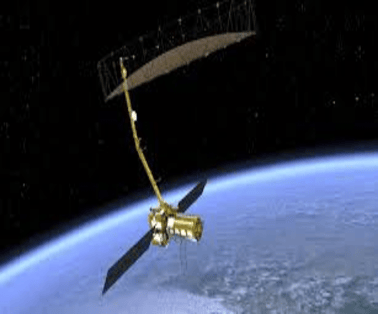
The NISAR satellite (NASA-ISRO Synthetic Aperture Radar) represents the first hardware-level satellite mission jointly developed and executed by ISRO and NASA, marking a landmark collaboration in space exploration. With an expected minimum mission life of three years, extendable up to five years, this high-resolution radar platform provides scientists with an unyielding look at the planet’s dynamic surface forces.
From Vision to Liftoff: The Historical Timeline of the NISAR Satellite
The concept of a dual-frequency, space-based radar platform took nearly two decades of persistent engineering and diplomatic coordination to transition from a theoretical framework into a fully integrated flight model:
- 2007–2008 (The Initial Blueprint): The core idea emerged from a US scientific panel recommendation advocating for a dedicated space mission to map land deformation, ecosystem structures, and ice dynamics. NASA officially commenced early conceptual designs in 2008, evolving the framework from a previously shelved project called DESDynI.
- 2012–2014 (The Bilateral Alliance): Recognizing shared scientific objectives, ISRO officially joined the project in 2012 to incorporate advanced agricultural monitoring and localized landslide detection capabilities. The formal bilateral agreement cementing the joint mission was signed in 2014.
- 2016–2020 (Instrument Fabrication): Detailed design phases kicked off in 2016. Intensive engineering split between North America and South Asia resulted in the successful completion of the L-band and S-band radar payloads by late 2020.
- 2021–2023 (Integration and Testing): The delicate radar subsystems were brought together for comprehensive environmental, thermal vacuum, and vibration testing to guarantee operational survivability. In 2023, the fully assembled, 2,800 kg flight module was safely transported to Sriharikota for final integration, earning its title as the most expensive satellite ever built by India.
Technical Specifications: What Makes the NISAR Satellite Unmatched
The core capabilities of the NISAR satellite are powered by an array of sophisticated engineering features that differentiate it from traditional optical imaging systems:
Dual-Frequency Synthetic Aperture Radars (SARs)
NISAR is the first satellite in history to simultaneously deploy two distinct radar frequencies to image the exact same terrestrial coordinates:
- L-band SAR (24 cm wavelength): Manufactured by NASA, this longer microwave signal easily penetrates dense tree canopies, forest vegetation, sand, and ice sheets to map the underlying bedrock and measure absolute wood trunk biomass.
- S-band SAR (12 cm wavelength): Manufactured by ISRO, this shorter wavelength is highly sensitive to surface textures, making it ideal for tracking agricultural crop maturity, water stress, and changing coastline boundaries.
SweepSAR Architecture and Mapping Capabilities
The satellite utilizes a specialized SweepSAR design that allows it to collect wide-swath radar imagery across a 242-kilometer-wide strip in a single pass without sacrificing high spatial resolution. Operating from a sun-synchronous orbit at an altitude of 747 kilometers with an inclination of 98.4°, the observatory scans and maps the entire landmass and ice sheets of the globe every 12 days.
Massive Antenna Array and Data Downlink Capacity
To capture these highly sensitive signals, the satellite carries a 12-meter-wide deployable mesh reflector antenna—the largest wire-mesh reflector ever built and launched by NASA. This array feeds an enormous data processing pipeline, generating up to 80 terabytes of data daily (nearly three times more data than any existing Earth observation satellite). This data stream downlinks at a rate of 26 terabits per day over specialized Ka-band and S-band ground station networks split between India and the United States.
Core Operational Objectives of the Joint Mission
The synchronous dual-band imagery provided by the NISAR satellite gives researchers an unfiltered view of the planet’s surface independent of cloud cover, smoke, rain, fog, or local time of day. The mission focuses on four main observation areas:
- Land and Ice Deformation: Tracking subtle crustal movements smaller than a single centimeter to improve predictive modeling for earthquakes, active volcanic swelling, localized landslides, and deep glacier melting rates.
- Ecosystem and Biodiversity Monitoring: Mapping global forest cover, tracking biomass changes, and cataloging carbon storage shifts to assess real-time ecosystem disturbances.
- Agricultural and Seasonal Hydrology: Observing seasonal crop cycles (such as corn, soybean, and rice), checking regional groundwater variations, monitoring water bodies, and assessing mountain snow accumulation.
- Oceanic and Near-Shore Processes: Recording sea-level rise patterns, observing marine environment shifts, and providing near-real-time data for emergency disaster response teams following tsunamis or major floods.
Financial Architecture: The Shared Layout of the Partnership
Developing and launching a heavy radar platform required a massive, balanced distribution of capital and engineering labor between the two space agencies:
- NASA’s Contribution (~$1.16 Billion USD): Directed toward providing the high-power L-band SAR system, the 12-meter deployable mesh reflector antenna, high-precision GPS tracking control receivers, a high-capacity solid-state data recorder, and the heavy data downlink subsystems.
- ISRO’s Contribution (~$90 Million USD): Directed toward manufacturing the specialized S-band SAR system, modifying the three-axis stabilized I3K spacecraft bus, constructing the mission control interfaces, providing the GSLV rocket, and managing the live launch logistics.
What is the GSLV-F16 Launch Vehicle?
Because the fully fueled NISAR satellite weighed a massive 2,800 kg and required precise injection into a high polar orbit, ISRO deployed its Geosynchronous Satellite Launch Vehicle (GSLV-F16). Standing approximately 51 meters tall (equivalent to a 17-story building) with a lift-off weight of 420 tonnes, the rocket operates using three distinct combustion stages:
- First Stage: A high-thrust solid rocket motor that ignites initially to break launch-pad inertia.
- Second Stage: Four liquid-fueled strap-on boosters that fire concurrently to maintain high atmospheric acceleration.
- Third Stage (Cryogenic Upper Stage): A highly sophisticated engine utilizing super-chilled liquid hydrogen (at –253°C) and liquid oxygen (at –183°C) to deliver the powerful, highly precise final push necessary to inject heavy payloads accurately into their final orbits.
Comparative Analysis: Global Radar Eyes in the Sky
While other countries operate active space-based radar platforms, the dual-frequency capability of the NISAR satellite marks a major leap forward in remote sensing:
| Satellite Mission | Operating Country / Agency | Radar Band & Wavelength | Technical Configuration & Limitations |
| Sentinel-1 | European Space Agency (ESA) | C-band (~5.4 GHz) | Single-frequency constellation; widely used for open environmental data but lacks deep vegetation penetration. |
| RADARSAT | Canada | C-band (~5.3 GHz) | Single-frequency system; narrower swath widths, longer revisit cycles, and commercially restricted data access. |
| ALOS | Japan | L-band (1.27 GHz) | Single-frequency platform; excellent for forest monitoring but lacks the finer surface resolution of a dual-band network. |
| TerraSAR-X | Germany | X-band (~9.6 GHz) | Shorter 3 cm wavelength; provides ultra-high resolution (~1m) but scans significantly smaller area swaths. |
| NISAR Satellite | United States & India (NASA / ISRO) | Dual L-band & S-band | First dual-frequency simultaneous imaging system; uses SweepSAR tech for massive swaths and 12-day global revisits. |
Historical Context: From Technical Denial to Space Self-Reliance
The deployment of a NASA payload aboard an indigenous Indian rocket powered by a cryogenic upper stage represents a major shift in international space relations, coming a long way from the geopolitical challenges India faced in the 1990s.
The 1990s Cryogenic Embargo
In the early 1990s, ISRO successfully developed the Polar Satellite Launch Vehicle (PSLV), capable of placing lighter payloads into Low Earth Orbit. However, launching heavier communication and scientific weather satellites weighing over 2,000 kg into deeper orbits required advanced cryogenic engine technology. Lacking this capability, India looked abroad for technical options.
In January 1991, ISRO signed a historic $200 million agreement with Russia’s Glavkosmos to procure cryogenic engines alongside a full transfer of technology blueprints. However, the United States invoked the Missile Technology Control Regime (MTCR), claiming the technology could be diverted for ballistic missile development. In 1992, the US imposed economic sanctions on ISRO and Glavkosmos, successfully blocking the technology transfer. A revised contract left India with only seven fully assembled Russian KVD-1 engines, with strict clauses preventing any structural modifications or blueprint sharing.
The Indigenous Cryogenic Programme and the Espionage Setback
Recognizing its strategic vulnerability, Prime Minister P.V. Narasimha Rao formally approved India’s own indigenous cryogenic development programme in April 1994. While development was underway, the project faced a severe setback in late 1994 due to the false espionage arrests of project leads Nambi Narayanan and Sasi Kumaran. The subsequent media attention and intense interrogations ground the program to a complete halt, though the Central Bureau of Investigation (CBI) eventually cleared both scientists of all charges, leading to a Supreme Court compensation award for wrongful prosecution in 2018.
Throughout the early 2000s, India’s initial flight tests using domestic cryogenic prototypes suffered repeated mid-flight failures and engine underperformance. However, on January 5, 2014, ISRO achieved a major milestone with the successful launch of the GSLV-D5 mission, powered by a 100% indigenous cryogenic upper stage.
The fact that this complex technology is now used to launch a premium NASA payload highlights India’s journey toward scientific resilience and space self-reliance. This integration mirrors deeper geopolitical alignments, with India’s signing of the Artemis Accords and Group Captain Shubhanshu Shukla’s participation in a NASA-facilitated mission to the International Space Station, signaling a mature, collaborative partnership on the global stage.
Read More
- Labour Policy: New Labour Codes 2026: Impact on Social Security and Wages