The ancient Silk Road, a pivotal network of trade routes connecting Europe and Asia, underwent a significant change in its main path. A recent study by Chinese scientists reveals that climate change was the primary driver of this historical shift, profoundly impacting ancient trade routes and geopolitical landscapes.
Key Discoveries & Characteristics of the Silk Road
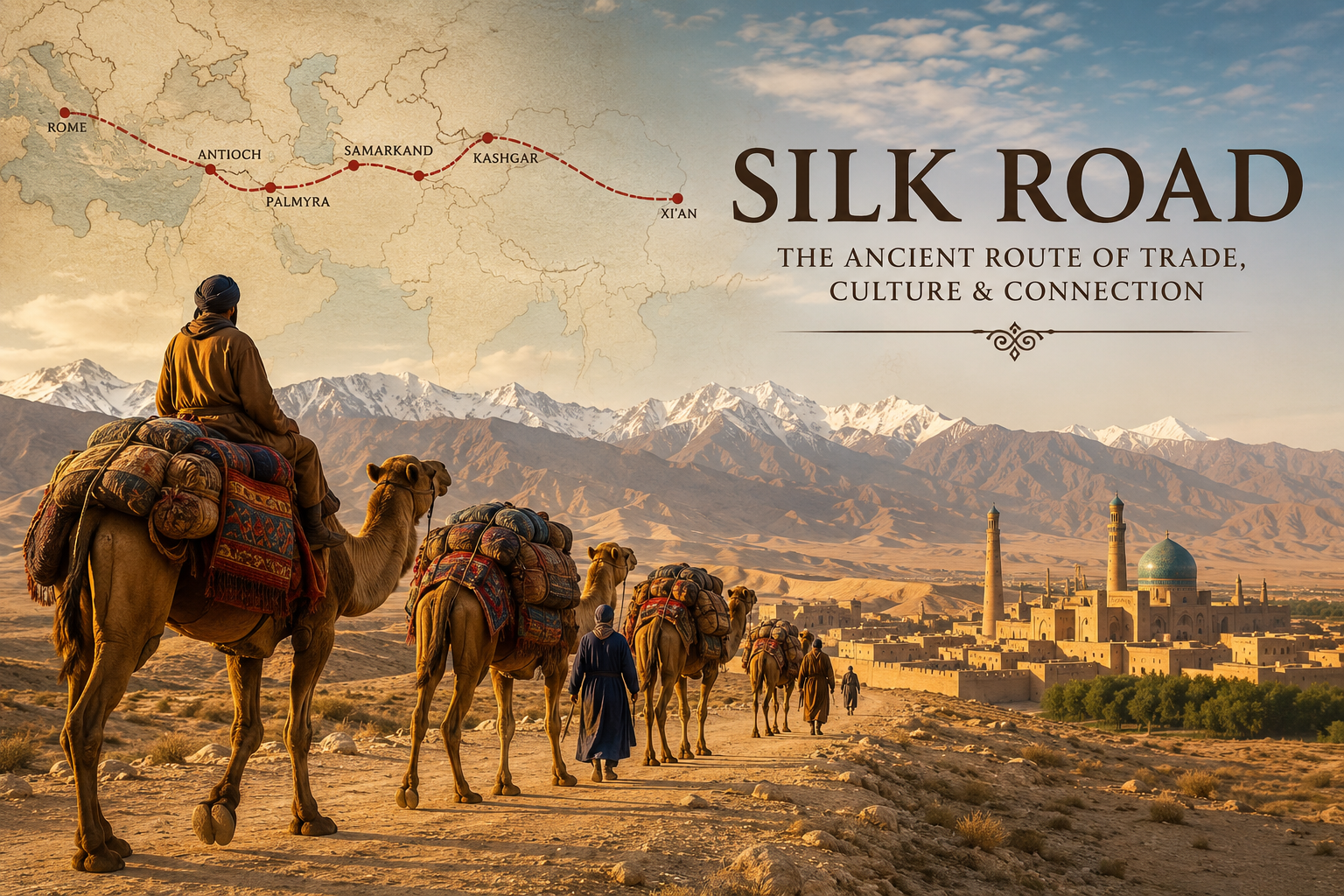
- Vast Connection: The Silk Road was an immense ancient path, linking the Atlantic seaboard of Europe with the Pacific coast of Asia.
- Original Route: Initially, the main Silk Road trade route passed through the Tarim River basin in what is now Xinjiang.
- Name Origin: The route derived its name from the immense silk trade established by China, which was at the easternmost end of the ancient trade network.
- Major Hubs: The Silk Road connected many important cities and great kingdoms, including Samarkand, Babylon, and Constantinople.
- Diverse Goods: Beyond silk, the Silk Road facilitated the transportation of various goods, such as spices, gold, and precious stones.
- Growth Factors: Increased trade over the centuries was driven by advances in ancient technologies, along with the rich exchange of culture and lifestyles.
- Geopolitical Importance: The Silk Road was later chosen as a vital path for geopolitical developments.
History of the Silk Road
- Over 1,500 Years: The Silk Road has a rich history spanning over 1,500 years, with established contacts between Europe and China dating back to the 2nd century BCE.
- Emperor Wu’s Initiative: Emperor Wu of the Chinese Han Dynasty dispatched his diplomat Zhang Qian to the ‘Western Regions’ (today’s Xinjiang and areas farther west).
- Mission Objective: Zhang Qian’s mission aimed to build relations with the Yuezhi and Wusun, enemies of the powerful Xiongnu tribal confederation threatening Han China.
- “Father of the Silk Road”: Zhang Qian’s travels through the ‘Western Regions’ earned him credit as the ‘Father of the Silk Road’.
The Original Silk Road Route (Background)
- Tarim Basin Route: For centuries, caravans traveling to and from China’s capital of Xian used the Silk Road route that skirted the Tarim Basin.
- Geographical Features: The Tarim Basin is enclosed by the Tianshan mountains to the north, the Kunlun mountains to the south, and the Pamirs to the west. The Takla Makan Desert lies within the Basin.
- Western Reach: Caravans traveled west from the Basin to the Levant (today’s Syria, Jordan, the Holy Land, and Lebanon) and Anatolia.
- Sea Connection: Goods were transferred to ships at Mediterranean ports for further transport to Western Europe.
- Crucial Role: This route was crucial for the flow of goods, people, ideas, religions, and even diseases across Eurasia, playing avital role in cultural exchange and economic exchange.
Shift to the Northern Silk Road Route
- ~420-850 CE Shift: During approximately 420-850 CE, caravans stopped using the route skirting the Tarim Basin.
- New Northern Path: They began using the northern slopes of the Tianshan mountains in the Junggar Basin in northern Xinjiang, historically called Dzungaria.
- Replacement Route: This new “Northern Silk Road route” along the northern Tianshan slopes was established centuries later as a replacement for the previous Tarim Basin trade route.
- Cultural & Political Impact: The rise of this Northern Silk Road route promoted Turco-Sogdian cultures and connected Chinese dynasties with nomadic regimes like the Khazar Empire, facilitating commerce across Eurasia.
The Reason for the Silk Road’s Route Shift
- Climate Change Evidence: Researchers used chironomid (‘lake flies’) fossils to reconstruct past climate, revealing a period of cooling and drying (420-600 CE) in the Tarim Basin.
- Water Scarcity: This climate change led to colder temperatures and less precipitation, causing a decline in meltwater and precipitation in the Tarim Basin, making the traditional route less viable due to water scarcity.
- Northern Route’s Advantage: Caravans switched to the northern route along the Tianshan mountains because it offered more abundant and stable water resources.
- Geopolitical Influence: Even after the Tarim Basin climate improved (600-850 CE), the trade route remained on the northern Junggar Basin route due to the rise of the Tubo Kingdom (Tibet) south of Xinjiang.
- Clash with Tang Dynasty: The Tubo Kingdom’s expanding power clashed with China’s Tang Dynasty, making the traditional Tarim Basin route less safe or politically favorable for trade.
Decline of the Silk Road
- Ottoman Empire’s Rise: The rise of the Ottoman Empire in present-day Turkey caused a separation of the Eastern and Western worlds, which had been connected by the Silk Road.
- Trade Closure (1453): In 1453, the Ottoman Empire closed off trade with the West and imposed highly unaffordable taxes on the Silk Road path.
- Demand for Goods: Europeans had become accustomed to goods from the East, leading to a need for an alternative route for trade when the Silk Road closed.
- Discovery of Sea Routes: This demand spurred the discovery of new sea routes, which eventually replaced the traditional Silk Road for East-West commerce.
Revival of the Silk Road
- China’s OBOR Initiative: China’s strategic initiative, OBOR (One Belt One Road), also known as the Belt and Road Initiative, is an attempt to revive the concept and purpose of the Silk Road.
- Enhanced Connectivity: Its main objective is to enhance connectivity with over 60 countries across Asia, East Africa, and Europe.
- Geographic Corridors: Key geographic corridors under this initiative connecting East with West include:
- China Pakistan Economic Corridor
- New Eurasian Land Bridge Economic Corridor
- Indo-China Peninsula Economic Corridor
- China Mongolia Russia Economic Corridor
- China Central Asia West Asia Economic Corridor
- China Myanmar Economic Corridor
To Download Monthly Current Affairs PDF Click here
Click here to get a free demo
Discover all about CLAT Exam