Two United States Senators have introduced a bipartisan resolution in the upper chamber of Congress reiterating that the US recognises the McMahon Line as the international boundary between China and India in Arunachal Pradesh
US On McMahon Line
- US Senators Bill Hagerty and Jeff Merkley have introduced a bipartisan resolution that reaffirms the United States’ recognition of Arunachal Pradesh as an integral part of India
- The resolution also condemns China’s military aggression to change the status quo along the Line of Actual Control (LAC).
- The resolution emphasizes the importance of the US-India strategic partnership and the Quad in supporting a Free and Open Indo-Pacific region.
What Is The McMahon Line?
- The McMahon Line serves as the de facto boundary between China and India in the Eastern Sector.
- It specifically represents the boundary between Arunachal Pradesh and Tibet, from Bhutan in the west to Myanmar in the east.
- China has historically disputed the boundary and claims the state of Arunachal Pradesh as part of the Tibetan Autonomous Region (TAR).
Background Of McMahon Line
How Was The Border Between British India And China Decided?
- The 890-km border from the corner of Bhutan to the Isu Razi Pass on the Burma border was drawn largely along the crest of the Himalayas, following the “highest watershed principle”.
- This principle basically drew the border along the highest ridge between two river plains.
- However, exceptions were made. Notably,Tawang, which would have been a part of Tibet had this principle been uniformly implemented, was included in British India due to its proximity to the Assam Valley.
- As the War of 1962 would show, capturing Tawang would give an invading Chinese army easy access to the valley in the south, affirming McMahon’s decision to include Tawang under British jurisdiction.
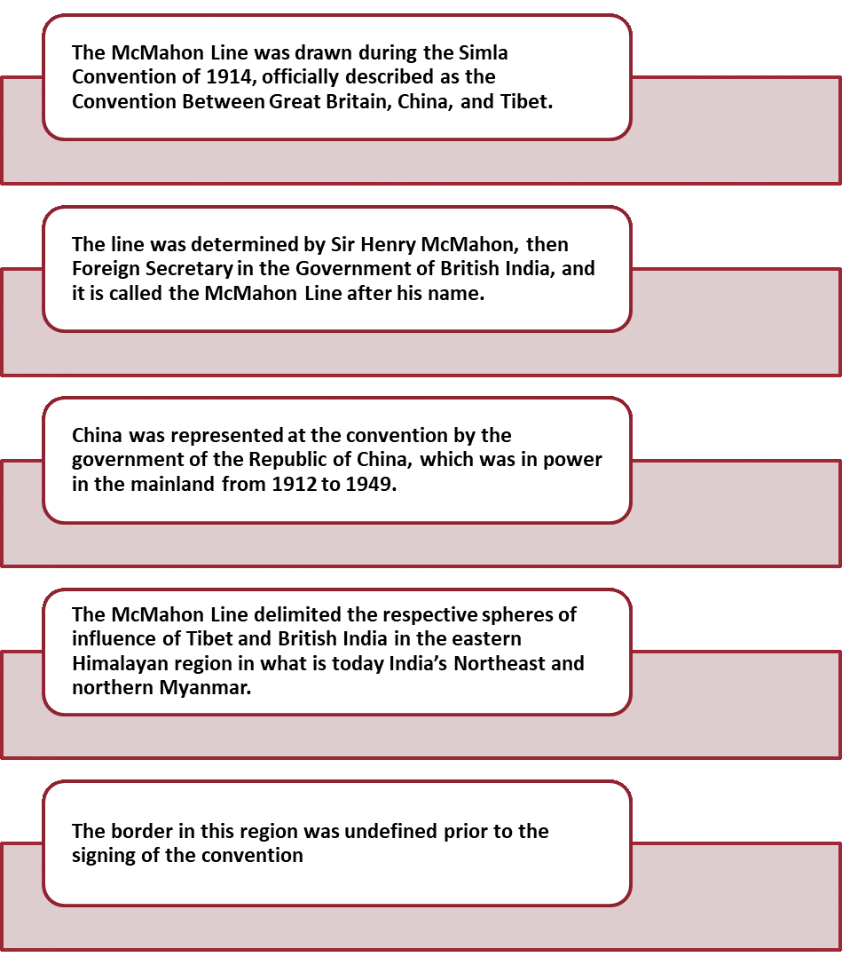
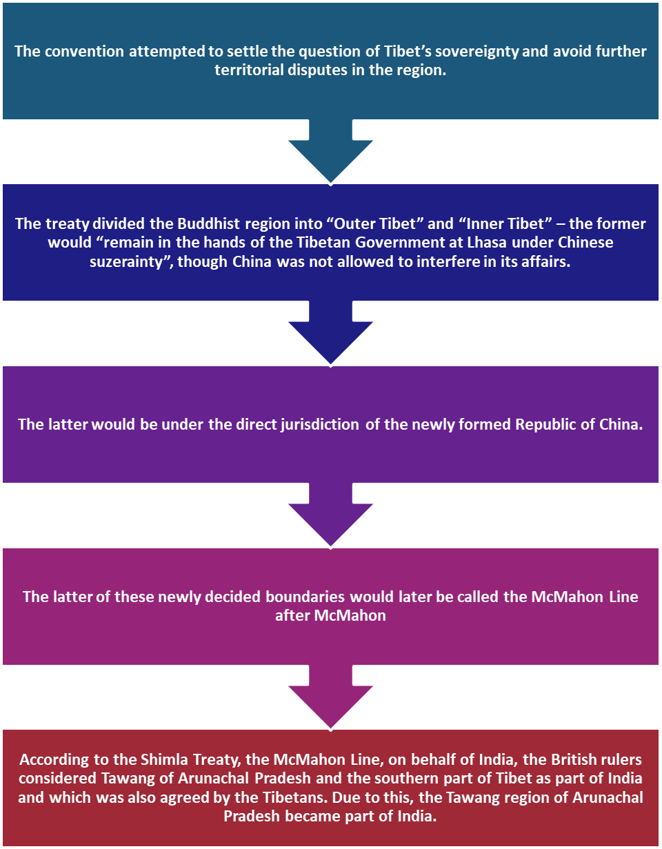
Simla Convention of 1913-14
China on McMahon Line
- The McMahon Line was a negotiation between India and Tibet without the participation of the Chinese government.
- China considers the Line illegal and unacceptable claiming that Tibetan representatives who had signed the 1914 Convention held in Shimla which delineated the line on the map were not having the right to do so.
- China government assert that the Chinese delegate Ivan Chan was not an authorized member during the line negotiation.
India on McMahon Line
- India believes that when the McMahon Line was established in 1914, Tibet was a weak but independent country, so it has every right to negotiate a border agreement with any country.
- Also, when the Line was drawn, Tibet was not ruled by China. Therefore, the Line is the clear and legal boundary line between India and China.
- Even after the Chinese occupation over Tibet in 1950, the Tawang region remained an integral part of India.
Current Status of McMahon Line
- While there were disputes regarding the McMahon line from the very beginning, after the communists took power in 1949, they pulled China out of all international agreements and the so-called “unequal treaties”
- During the 1962 Sino-Indian War,China was able to quickly overpower India and make deep inroads into Indian territory across the Line.
- India recognizes the Line and considers it to be the ‘Actual Line of Control (LAC)’ between India and China, while China does not recognize the Line.
- China says that the area of the disputed area is 2,000 kilometers while India claims it is 4,000 kilometers.
- This land dispute between India and China is in Tawang (Arunachal Pradesh), which China considers as the Southern part of Tibet
To Download Monthly Current Affairs PDF Click here
Click here to get a free demo
Everything About CLAT 2025
Frequently Asked Questions
The McMahon Line demarcates India’s legal border with?
The McMahon Line demarcates India’s legal border with China
The McMahon Line was drawn during which convention?
The McMahon Line was drawn during The Simla Convention
When India-China fought the deadliest war?
India-China fought the deadliest war in 1962